
Top Rated Caches

Ich als lebender APRS Cache mit meinem Handfunkgerät. Fang mich wenn Du kannst!
Me as living APRS Cache with my handheld radio. Catch me if you can!
Gridsquare: JN76GO86PS, Latitude: 46.611500, Longitude: 14.572000
Cache Type: Living, Difficulty: Easy, Terrain: Handicapped accessible
2
From OE8APR
D-Star und C4FM Repeater im Lachtal
C4FM 70cm 438.675MHz -7.6MHzD-Star 2m 145.700MHz -0.6MHz
Gridsquare: JN77EG53KP, Latitude: 47.265167, Longitude: 14.378667
Cache Type: APRS, Difficulty: Easy, Terrain: Suitable for small children
3
From OE6POD

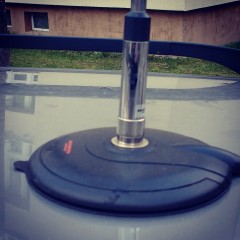
This WeatherStation is build with a Raspberry Pi 1 and a RTL2838UHIDIR SDR USB stick to operate as RX only iGate.
It uses a modified fowsr version to get the weather data from a WX-2008 weahter station per USB. This modified version of fowsr provides the needed Json formatted weather data for the i…
Gridsquare: JN76GO86PU, Latitude: 46.611833, Longitude: 14.572167
Cache Type: APRS, Difficulty: Easy, Terrain: Handicapped accessible
2
From OE8APR
Bin als mobiler Cache in Berlin und im Umland unterwegs.
Gridsquare: JO62VM43RL, Latitude: 52.5145, Longitude: 13.7895
Cache Type: Living, Difficulty: Average, Terrain: Suitable for small children
1
From DM9KS
Finde den Amarok.
Meistens im Raum West Tirol unterwegs.
Er wurde aber auch schon in Bayern oder Sachsen gesichtet!
Gridsquare: JN57RF58HS, Latitude: 47.2448333333333, Longitude: 11.4608333333333
Cache Type: Living, Difficulty: Easy, Terrain: Handicapped accessible
6
From OE7JVT
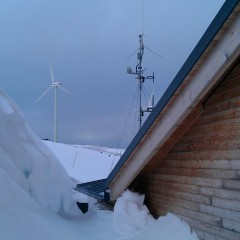
Eine (die einzige in Zeltweg) Amateurfunkantenne und eine Wetterstation.
Gridsquare: JN77IE96ED, Latitude: 47.1923333333333, Longitude: 14.7433333333333
Cache Type: APRS, Difficulty: Easy, Terrain: Handicapped accessible
3
From OE6POD

Auf der Fahrt durch das Ötztal / Tirol / Austria über die Timmelsjoch-Hochalpenstrasse nach Südtirol lässt sich dieser Cache leicht finden.
-----
On the journey through the Ötztal / Tirol / Austria on the Timmelsjoch high alpine road to South Tyrol can this cache find easily.
Gridsquare: JN58VI45CF, Latitude: 48.355167, Longitude: 11.784167
Cache Type: APRS, Difficulty: Easy, Terrain: Handicapped accessible
1
From OE7JVT
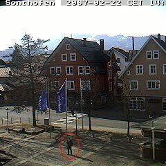
Begib Dich zu oben genannten Koordinaten und schau in
Richtung Rathaus.
Das Bild wird alle 15 min aktualisiert, dann bitte lächeln
und winken.
Die Webcam findet sich unter:
http://www.sonthofen.de/aktuell/livecam.php3
Viel Spaß beim schnelle Cac…
Gridsquare: JJ00AA00AA, Latitude: 0.000000, Longitude: 0.000000
Cache Type: GeoCache, Difficulty: Easy, Terrain: Handicapped accessible
0
From OpenCaching

Gridsquare: JJ00AA00AA, Latitude: 0.000000, Longitude: 0.000000
Cache Type: GeoCache, Difficulty: Easy, Terrain: Handicapped accessible
0
From OpenCaching
This cache location is inside Springbrook Park! This park offers beautiful walking and biking trails along the Maryville-Alcoa Greenway. Both cities have spent a lot of time and money to provide this greenway system to citizens and the views are beautiful! It travels along large creeks, parks, dog p…
Gridsquare: EM85AS57CX, Latitude: 35.783333, Longitude: -83.957333
Cache Type: GeoCache, Difficulty: Easy, Terrain: Handicapped accessible
1
From N2AL
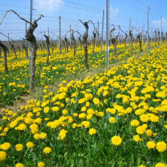
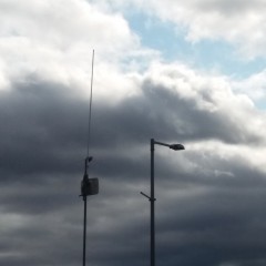
Ein APRS Digi/I-Gate im schönen Rheingau.
Wandern in den Weinbergen mit anschließendem Einkehren in eine Straußwitschaft wird dringend empfohlen
Gridsquare: JN39XX46SP, Latitude: 49.9860392832204, Longitude: 7.9563694785864
Cache Type: APRS, Difficulty: Easy, Terrain: Handicapped accessible
1
From DK5ES
1200m alt env...au dessus de ST PAUL capital de la zone balneaires de la cote ouest
Gridsquare: LG78OX35XE, Latitude: -21.043547, Longitude: 55.327876
Cache Type: GeoCache, Difficulty: Easy, Terrain: Handicapped accessible
0
From FR4PV
Summit: DM/NS-008Name: SchalkeAltitude: 762m, 2499ftPoints: 8Summit data is kindly provided by SOTA API
Gridsquare: JO51EU54XD, Latitude: 51.850600, Longitude: 10.383100
Cache Type: SOTA, Difficulty: Challenging, Terrain: NOT suitable for small children
1
From SOTA
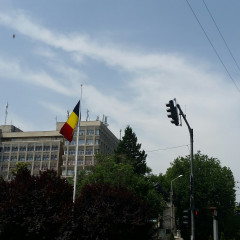
YO3KXL-10 Digipeater is hosted and maintained by the Electronics,Telecommunications and Information Technology University from Bucharest. This is the most important APRS node within YO3 area. In the same premises is hosted the main node of the RoLink network, the Romanian VHF/UHF wide coverage ham r…
Gridsquare: KN34AK64UC, Latitude: 44.4338333333333, Longitude: 26.0571666666667
Cache Type: APRS, Difficulty: Easy, Terrain: Handicapped accessible
0
From YO3FVR